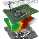
What imagery collection mechanism can be scheduled independent of cloud cover, at a fraction of the cost of contracting an aerial survey, at resolutions tens of times more detailed than satellite images, and with custom collection areas editable by you, the customer, up to minutes before flight time? Answer: Unmanned Aircraft Systems (UAS).
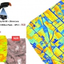
Pro Mac offers high reliability UAS as a platform for “Intelligence Gathering”. Through this hi-tech and high reliability UAS platform, it can integrate with techniques of data processing and analyzing for relative study fields such as:
- City Development
- GIS and Remote Sensing
- Forestry
- Agricultures
- Safety Assessment
- Academic Research.